1. Europe at the time of the Karolingers
2-5. Historical English maps of Bulgaria
6. Bulgaria at the time of Asparuch and Terwel
1. — Europe at the time of the Karolingers.
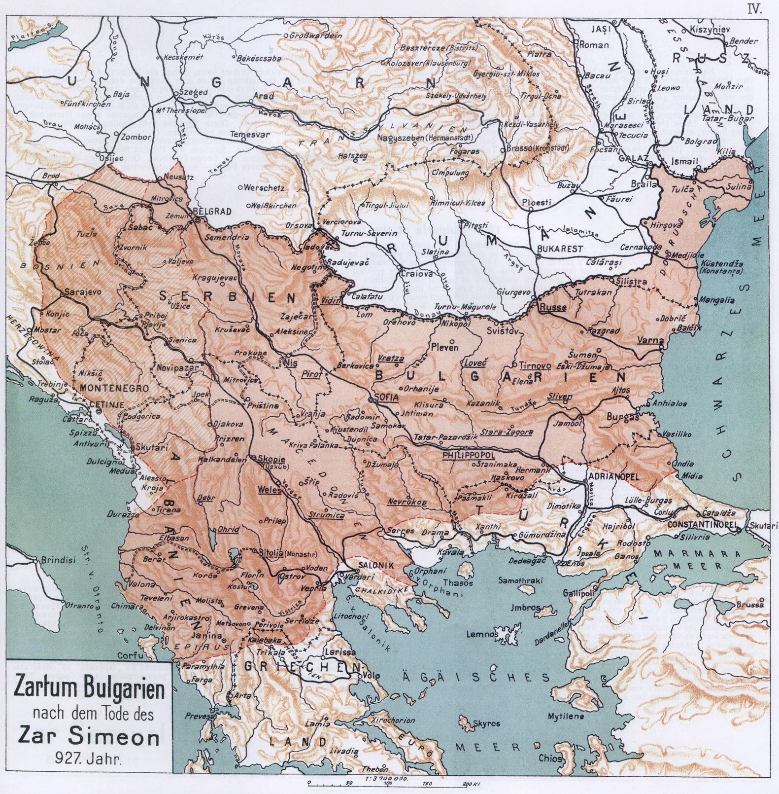
This map is reproduced from Spamers „Illustrated History of the World” and shows Europe at the time of the Karolingers who, as is known, reigned in Germany from 752-911. On this map the frontiers of the first Bulgarian Empire of that epoch are not drawn with full historical accuracy. A correction, therefore, is necessary.
In the eight century (752-800) the Bulgarian State comprised the northern Bulgaria of to day, the northern Thracia, the southern part of Walachia and the southern Bessarabia; but the latter is not indicated as Bulgarian territory on this map.
This map includes some districts in Bulgaria that in the ninth century (801-900) did not belong to it, Macedonia for instance during the reign of Krum; the north-west frontier followed the course of the Theiss, not that of the Danube; neither Albania nor Epirus were Bulgarian territory under the rule of Pressiam and Czar Boris; eastern Hungary and Transsilvania had been already lost under Czar Simeon.
According to the treaty of 904, the Bulgarians of the tenth century (901—911) had an access to the Adriatic Sea at the time of the reign of Czar Simeon, in reality however they dominated over a far larger part of the coast as the map indicates. Unprecisely drawn are farthermore the frontiers of east Macedonia as well as the region of Salonica. It must also be mentioned that the commencement of the southern frontier has been wrongly put on the shore of the Black Sea; it began at a point far more south of the small town of Midia.
From all this it appears that the author of the map was not well versed in Bulgarian history and he therefore confounds the frontiers of the Bulgarian State of different periods.
In consequence of this error, this map allows a misconception about the extension of the Bulgarian Empire at the mentioned period in relation to the union of the Balkan-and Daci-Slavonians under Bulgarian rule.
In spite of this inferiority, this map has been reproduced here upon two considerations:
a) In order that one more map of the first Bulgarian Empire may be published drawn by a European man of science; b) in proof of the impartiality with which, this atlas has been put together, and the scientific objectiveness with which Professor Zlatarsky has demonstrated the historical developement of the Bulgarian State in his new maps.
1
![]()
( 1. — Europe at the time of the Karolingers )
2
![]()
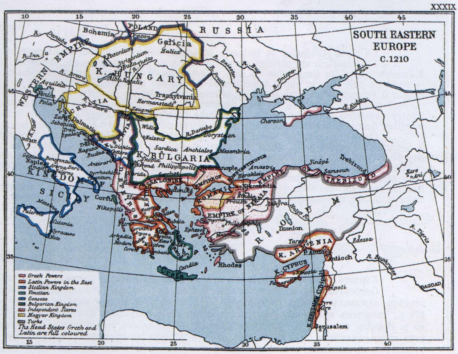
2—5. — Historical English Maps of Bulgaria.
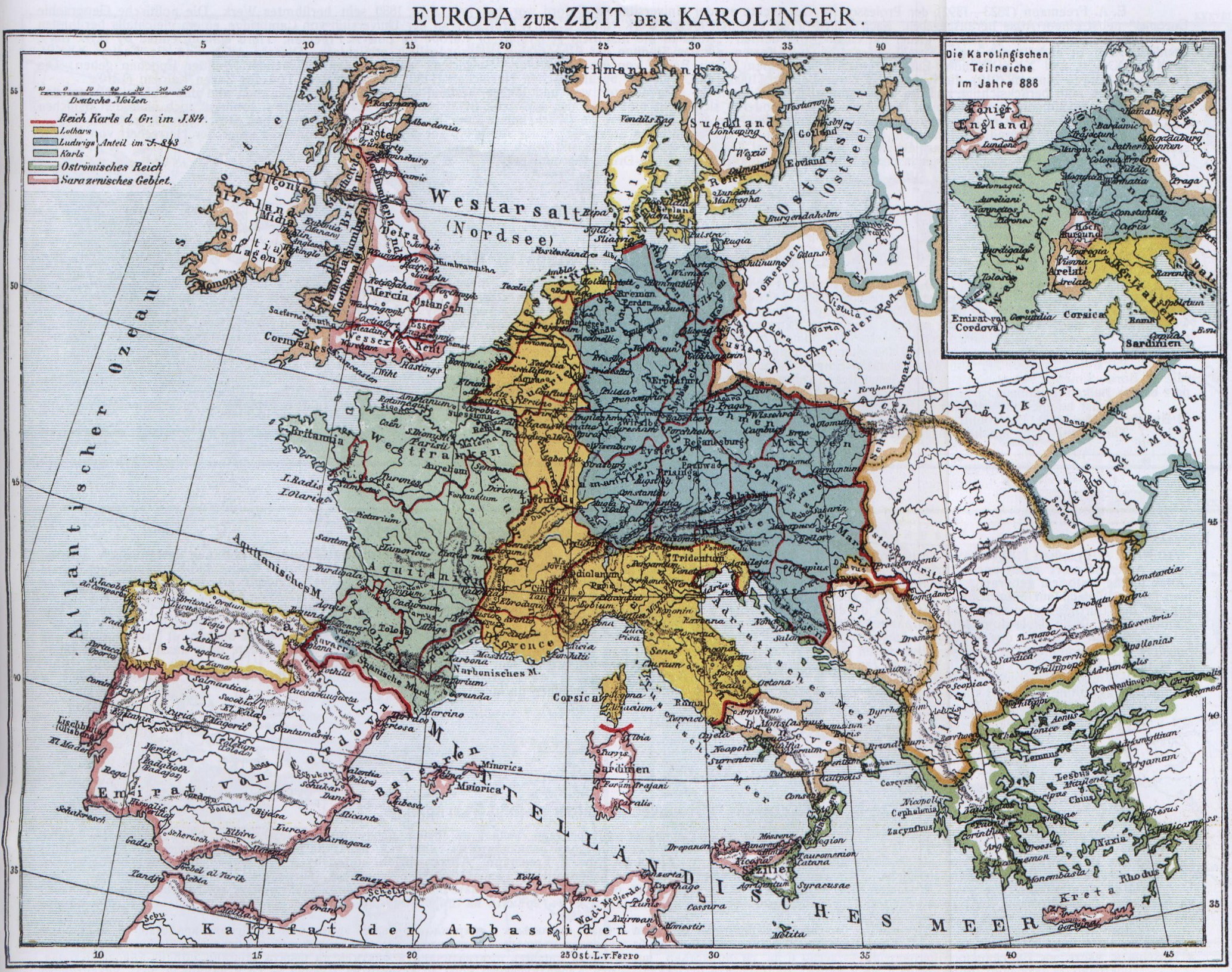
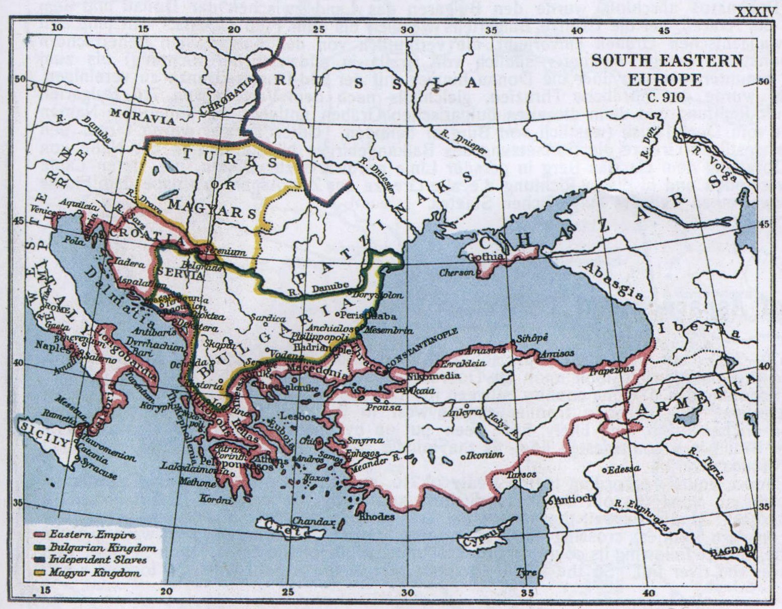
Mr. Е. A. Freeman (1823—1892) Professor of history at Oxford University, published, in the year 1880 his wellknown book „The Political Geography of Europe” with an atlas. After his death this work of his reappeared in 3th edition, edited by Mr. Е. В. Bury, Professor at Cambridge University and equally renowned historian, again with an atlas entitled: „Atlas to the historical geography of Europe by Edw. A. Freeman. Third edition, edited by J. B. Bury, London 1903”. It contains a large number of well-workedout maps which make the study of geography extraordinarily easy. From this atlas the maps XXXIV, XXXV, XXXVIII, and XXXIX of Southeast-Еurope are reproduced in order to give a clear conception of the development of Bulgaria during four succeeding epochs: the period of Czar Simeon (910), the period of Czar Samuel (1000), the end of the Byzantinic domination (1180) and after the death of Czar Kaiojan (1210).
Regarding the fact that the West-Bulgarian Empire Samuel's had a greater extension and a longer existence than the Servian under Duschan, and that under the rule of Boris Simeon Peter, Kalojan, Iwan Assen II and others, Bulgaria not only extended herself over the Servian dominion of Duschan's time, but also over the eastern part of the Balkan-Peninsula, it is easy to imagine how much the Servians exaggerate the occurrences of their modest history of the Middleages.
It must be specially established, that even at the time when the Bulgarian State, from the Adriatic Sea to the mouth of the Danube, stood under the rulership of Byzanz (1018—1184), the country went by the name of Bulgaria which is clearly to be seen out of map XXXVIII.
These four maps are here reproduced in fac-simile, on the scale of the original ones.
3
![]()
( 2—5. — Historical English Maps of Bulgaria )


4
![]()
6. — Bulgaria at the time of Asparuch and Terwel.
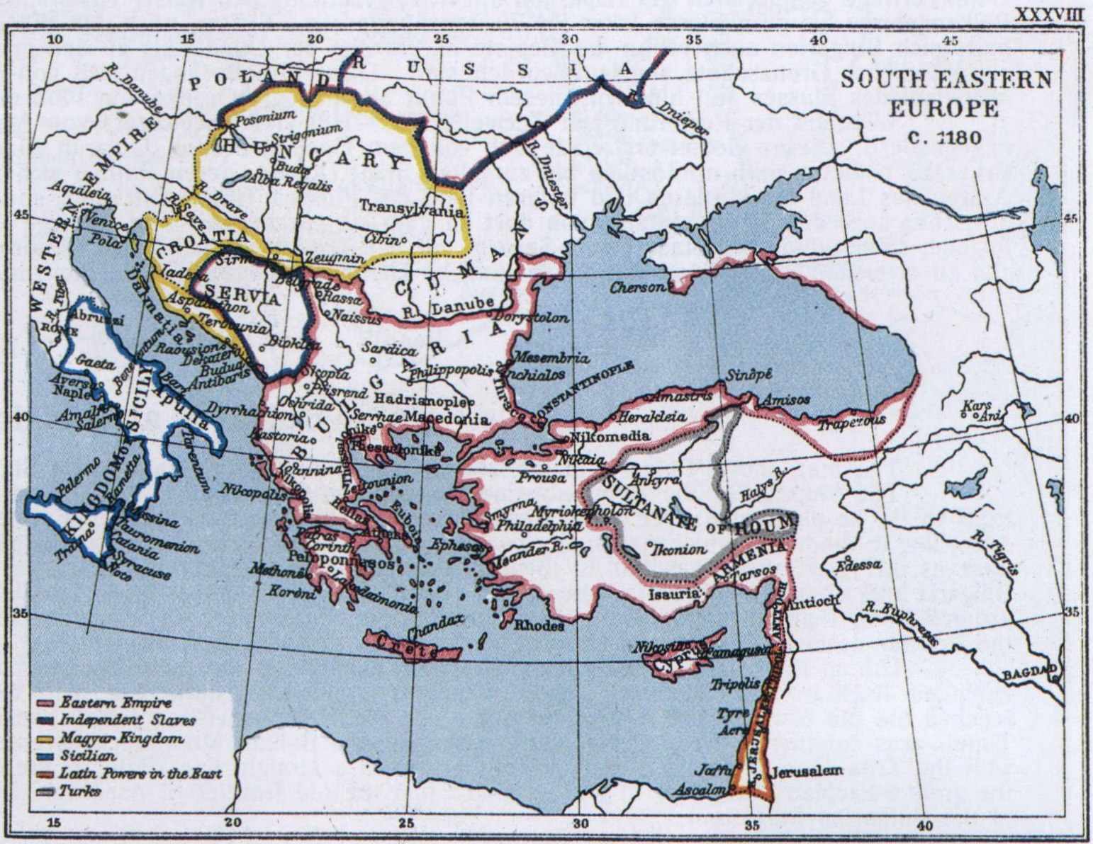
The map shows Bulgaria at the commencement of her existance as a State.
The founder of the first Bulgarian Empire was Asparuch, called Isperich (679—701). He, with his troops, about the year 660 settled down in the Dobrudja, from where he also ruled over south Bessarabia. This circumstance gives inducement to the historians to look upon the Dobrudja as the „cradle of the Bulgarian people”. According to the treaty which Asparuch closed with the Byzantinic Emperor Constantine IV Pogonatos in 679, the country between the Danube and the Balkan Mountains, as far west as the river Iskar, was left to the Bulgarians. Later on, after the defeat of the Avarians, the Bulgarian frontier ran up west to the river Ogosta. About that time Bulgaria had already incorporated the districts north of the Danube as far as the walachian ditches which, very likely, have been put up by the Bulgarian rulers as a natural protection for their frontier. These ditches went from the Danube (a few miles south of Braila in a southwesten line) to the middle part of the river Jiul; from this point the frontier descended along the river to unite itself across the Danube with that south of this river.
During the reign of Terwel (701—718), Asparuch's successor, the northern Thracia, equally according to the treaty of 716, was enclosed in Bulgaria. This district extended itself from the Sredna-Gora Mountains, in a southeastern line, and then northeast along the old Bulgarian ditches, known by the name of „Erkessija”, till it reached the old town Dewelt whose ruins are not far from the village Jakisli (west of Burgas). Under Terwel, the part of the Avarian country at the middle and lower river Timok, was conquered, so that the continuation of the Balkan Mountains became the western frontier, crossing the Timok near Zaitschar; from there it went parallel wiih the Zrna-Gora Mountains and Mount Garwan in a straight line north to the Danube, thence following its course in order to unite, south of the town Turnu-Severin, with the great walachian ditch, and to reach on this line the old frontier of Asparuch's time near the river Jiul. So the whole southern part of the present Walachia formed a part of the Bulgarian State under Terwel.
5
![]()
( 6. — Bulgaria at the time of Asparuch and Terwel )

6
![]()
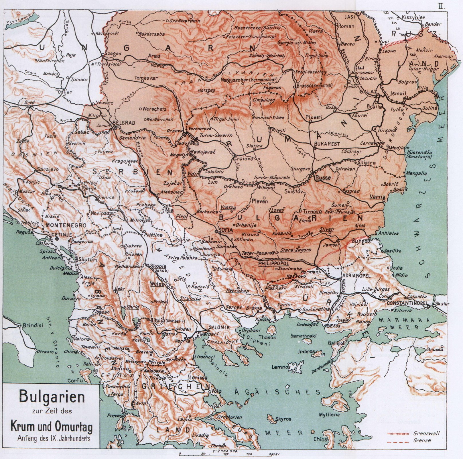
7. — Bulgaria at the time of Krum and Omortag.
After King Krum (802-814) had conquered the Avarians who, about 805, had been vanquished by the Franconians, he added to Bulgaria the territory lying east of the river Theiss (the present east Hungary and Transsilvania), by which the Bulgarians became immediate neighbours of the Franconians and Moravians. During Krum's reign were farthermore aggregated tô Bulgaria the territories south of the middle Danube, the districts of Branitschewo and Belgrade. In the course of continuous wars waged against Byzanz Krum conquered the town Serdika (the Sofia of to day) with all its province and devastated the district of Adrianople as well as the surroundings of Constantinoples. These wars were ended by a treaty closed 814—815 after Krum's death by his son and successor Omortag (814-831).
By this treaty a small territory east of the river Tundja was adjudicated to Bulgaria. On this side the frontier lowered itself therefore from the middle of the ditch of Erkissija between the rivers Tundja and Tschoban Asmak to the Sakar Mountains from whence it ran west, and ended in a south-eastern direction at the present village Usundjowo; from there it drew along the slope of the Rhodope Mountains to the Rilo Mountains, then farther, past the towns Dubnitza and Radomir to the Sucha Mountain and to the middle part of the Morava, and from this river again north-west to the river Kolubara. Later on, but stil during the reign of Omortag, the Bulgarians succeeded by a convention with the Franconians to expand their dominion over the country between the lower courses of the Sava and the Danube — the Srem province — and to secure for themselves the possession of the old city of Singidunum at the outflow of the Sava, which henceafter was called Belgrad (Servia's present capital).
This map shows the frontiers of Bulgaria under Krum and under Omortag.
7
![]()
( 7. — Bulgaria at the time of Krum and Omortag )
8
![]()
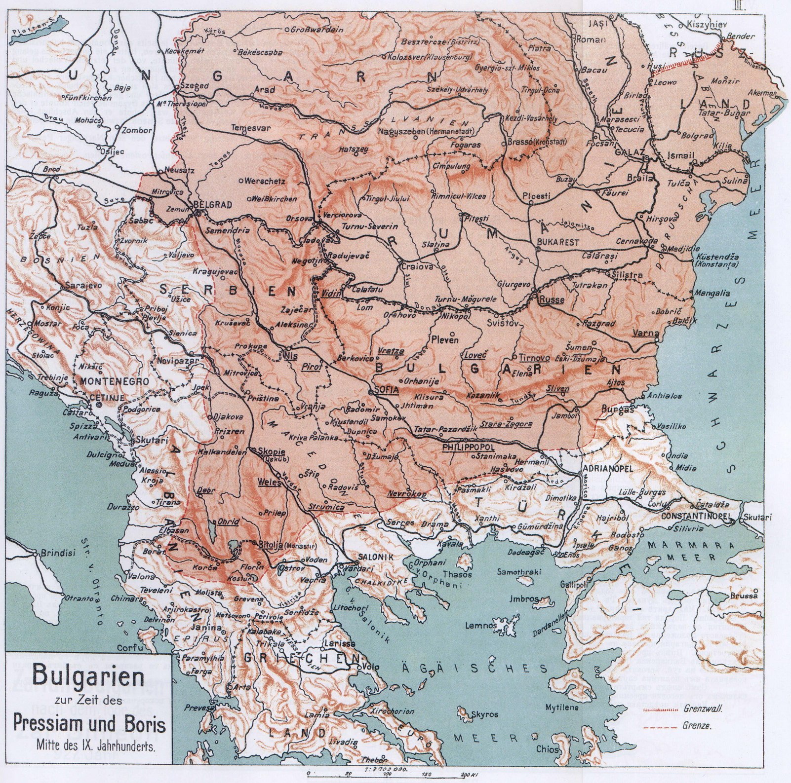
8. — Bulgaria at the time of Pressiam and Boris.
The rapid enlargement of the Bulgarian Empire began under Pressiam (836—853) who, profiting of the wars of the Byzantinic Emperor Theophiles against the Arabs, got very easily possession of the whole Macedonia of to-day as far as the Servian territory on the Ibar river and as far as Albania. To the south the Bulgarian frontier enclosed the regions of Kostur, Bitolia (Monastir), Moglen, Tikwesch and Strumitza up to the west Rhodopies. The union of all these territories to Bulgaria was officially recognised by the Byzantinic Government for the first time in the treaty of 864, concluded with the successor of Pressiam, Boris I (853—888) one year before the conversion of the Bulgarians to Christianity (865). This agreement determined more precisely the southern frontier of Bulgaria to which was also left the stretch of land along the middle and upper courses of the rivers Struma and Mesta.
The map shows the boundary of Bulgaria according to the treaty of 864.
9
![]()
( 8. — Bulgaria at the time of Pressiam and Boris )
10
![]()
9. — Bulgaria at the time of Simeon and Peter.
Nearly all possessions on the other side of the Danube had already been severed from the Bulgarian Empire during the first years of reign of the renowned ruler of the Bulgarians, Simeon (893—027). The Magyars, having been asked for help against the Bulgarians by the Byzantinic emperor Leon VI, called the philosopher, had conquered them. The Magyars succeeded to settle down in the valley between Theiss and Danube, whilst the Petschenegs, who followed them, took possession of to-day's Walachia and of Bessarabia. In consequence of these great territorial losses Simeon turned his full attention to the south and south-west. After the Bulgaro-Phigonic peace-treaty (896) according to which the Byzantinic Empire agreed to pay a war-indemnity, and not to call again upon other nations for help against the Bulgarians, Simeon, taking advantage of the difficult state of things in the Byzantinic Empire, annexed in a peaceful way South-Albania and a part of North-Epirus; and, after the treaty of 904 Bulgaria got an access to the Adriatic sea and won a seaway to countries outside of the Balkan-Peninsula, free of Byzantinic control. During the continuus wars of Simeon against the Byzantinic Empire, he was enabled to conquer the largest part of the Byzantinic possessions on the Balkan-Peninsula. As his aim, however, was the conquest of Constantinople, he declined a durable peace wich Byzance; therefore the gained territories could not be aggregated. On the other hand Simeon meanwhile took the opportunity to settle accounts with the Servians because of their perfidious policy, and he subjected them in the year 924. It was not till after Simeons death (May 27.927) that the political and ecclesiastical boundaries were finally fixed with the treaty which his successor, Peter, closed with Byzanz on the 8th of October 927.
This map delineates the boundaries of Bulgaria according to the sense of this treaty, and the north-westerly, white-hatsched part shows the subjected Servia.
11
![]()
( 9. — Bulgaria at the time of Simeon and Peter )